PLACE
GEOGRAPHY
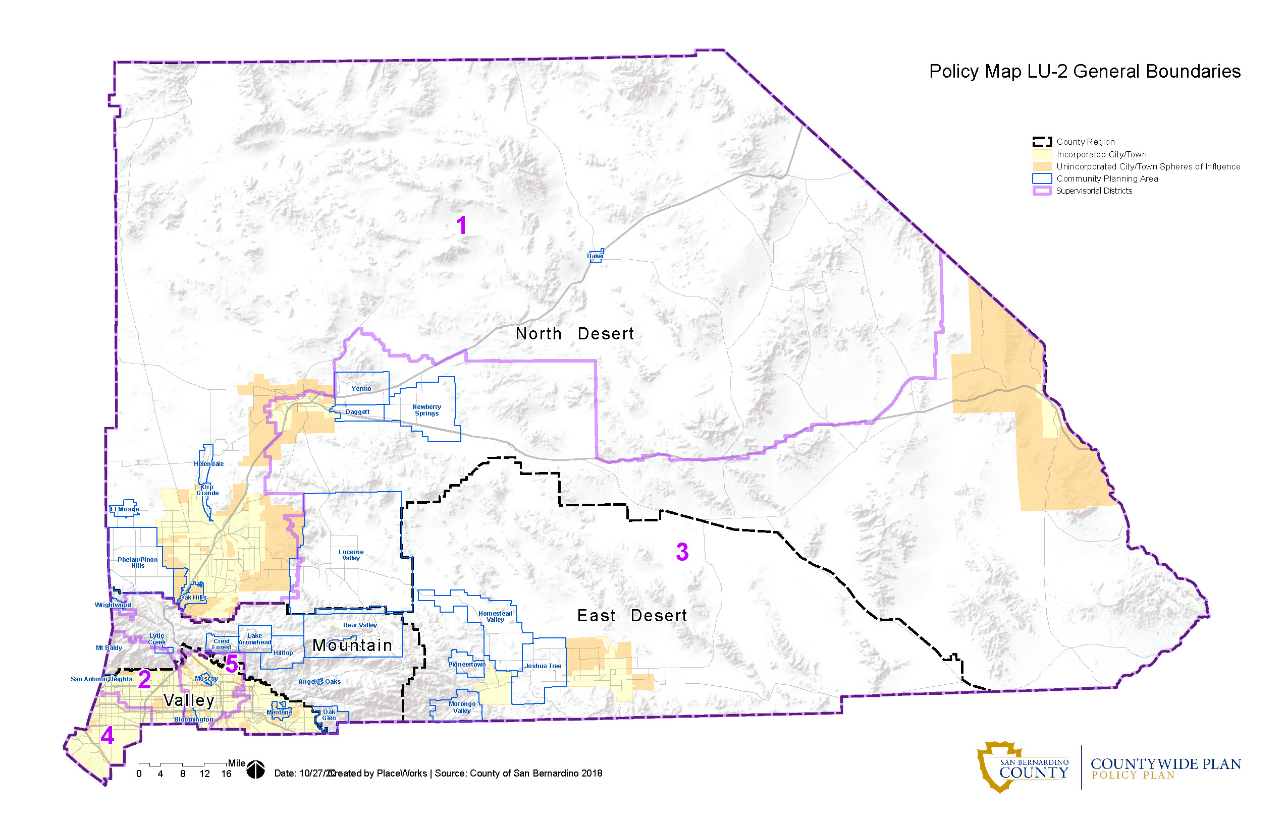
MOST CITIES ARE IN THE VALLEY DESPITE IT BEING SMALLEST REGION IN THE COUNTY
Cities and Major Unincorporated Areas in San Bernardino County, by Region
The Valley Region
2%
Percent of county’s total land area that is in the Valley Region
Mountain Region
4%
Percent of county’s total land area that is in the Mountain Region
East Desert Region
17%
Percent of county’s total land area that is in the East Desert Region
North Desert Region
77%
Percent of county’s total land area that is in the North Desert Region
Bloomington*
Chino
Chino Hills
Colton
Fontana
Grand Terrace
Highland
Loma Linda
Mentone*
Montclair
Muscoy*
Ontario
Rancho Cucamonga
Redlands
Rialto
San Antonio Heights*
San Bernardino
Upland
Yucaipa
Angelus Oaks*
Big Bear Lake
Bear Valley*
Crest Forest*
Hilltop*
Lake Arrowhead*
Lytle Creek*
Mt. Baldy*
Oak Glen*
Wrightwood*
Homestead Valley*
Joshua Tree*
Morongo Valley*
Pioneertown*
Twentynine Palms
Yucca Valley
Adelanto
Apple Valley
Baker*
Barstow
Daggett*
El Mirage*
Helendale*
Hesperia
Lucerne Valley*
Needles
Newberry Springs*
Oak Hills*
Oro Grande*
Phelan/Piñon Hills*
Victorville
Yermo*
KEY
*Unincorporated/Community Planning Areas
Incorporated City
Sources: San Bernardino County Countywide Plan, Policy Plan (https://countywideplan.sbcounty.gov/resources/maps-tables-figures/and Communities (https://countywideplan.sbcounty.gov/communities/) and Land Use Background Report; California State Association of Counties (www.counties.org)
20,105
Size in square miles of San Bernardino County, the largest county in the contiguous United States
24
Incorporated cities in San Bernardino County
24
Incorporated cities in San Bernardino County
LAND USE
82%
Land area that is federally owned
17%
Land area used for military purposes
22%
Land area dedicated to housing, industrial, utilities, agriculture, transportation, and parks
7,641
Acres of County regional parks
1,013
Acres of Special District parks
6.1 million
Acres of recreational land
PEOPLE
POPULATION
2,207,424
Population (2025)
2%
Projected growth between 2025 and 2045
POPULATION DENSITY
110
Persons per square mile (countywide)
3,266
Persons per square mile (Valley Region only)
AGE
In terms of absolute growth, younger age groups are expected to decline between 2025 and 2045. The number of children ages 0-5 years is projected to decrease by 13.6% during this time, while the number of children ages 6 to 17 years is projected to decrease by 29.9%, and the number of young adults ages 18 to 24 years is expected to decrease by 14.5%. All other age groups are expected to see population growth between 2025 and 2045, with seniors ages 65 years and older experiencing the highest rate of growth at 50%.
These trends are mirrored in California as a whole, yet the rates of change are less dramatic than in San Bernardino County. For example, the statewide population of children ages 0-5 years is expected to decrease by 9.0% over this period, and the population of children ages 6 to 17 years is projected to decrease by 24.7% statewide. The statewide senior population is projected to increase 45.7%.
In terms of relative growth, the proportion of the San Bernardino County population made up of residents ages 65 and older is projected to grow from 13.6% of the population in 2025 to 20.0% by 2045, and the proportion of residents ages 45 to 64 is expected to grow from 22.8% to 25.0%. The size of all other age groups is projected to remain constant or shrink in varying degrees relative to the total population.
SENIOR POPULATION TO EXPERIENCE FASTEST GROWTH RATE
Projected Change in Age Group Proportions of the Total San Bernardino County Population, 2025 and 2045
RACE AND ETHNICITY
At 56% of the total San Bernardino County population, Latino residents, who may be of any race, are the largest race and ethnic group in the county. The Latino population is projected to increase to 59% of the total population by 2045. The White population is projected to decrease as a proportion of the overall population, from 24% in 2025 to 19% in 2045, while the populations of individuals identifying as other racial groups are largely projected to remain the same.
RACIAL/ETHNIC COMPOSITION OF POPULATION PROJECTED TO CHANGE MODESTLY OVER NEXT 20 YEARS
Projected Change in Race/Ethnic Group Proportions of the Total San Bernardino County Population, 2025 and 2045
SOCIAL CHARACTERISTICS
22%
Born outside of the U.S.(2024)
46%
Speak a language other than English at home (2024)
3.2
Average household size (2024)
39%
Households with children under 18 (2024)
23%
Families with children under 18 led by a single parent (2024)
CIVIC ENGAGEMENT
64%
Voter turnout among population eligible to vote (2024)
80%
Voting by mail (2024)
2024 PRESIDENTIAL VOTER TURNOUT LOWEST IN LAST TWO DECADES
Turnout Among Registered Voters for Presidential and Mid-Term Election Years in San Bernardino County, 2004-2024
EDUCATION
24%
Residents over age 25 with a bachelor’s degree or higher (2024)
88%
High school graduation rate (2024/25)
The high school graduation rate has risen from 83.0% in the 2015/16 school year to 87.8% in the 2024/25 academic year.
2024/25 HIGH SCHOOL GRADUATION RATE HIGHEST OVER PAST 10 YEARS
High School Graduation Rate in San Bernardino County, 2016 – 2025
ECONOMY
EMPLOYMENT
1,054,700
Number in the labor force (December 2025)
1,001,600
Number employed (December 2025)
53,000
Number unemployed (December 2025)
5.0%
Unemployment rate (December 2025)
INCOME
16.4%
Child poverty rate (2024)
12.5%
Overall poverty rate (2024)
$88,294
Median household income (2024)
HOUSING
$497,000
Median single-family existing home price (Q4 2025)
51%
Buyers who can afford an entry-level home (priced at 85% of median) (Q4 2025)
TECHNOLOGY
97%
Percent of households with one
or more computing device (2024)
95%
Percent of households with
an Internet subscription (2024)
SOURCES
PLACE
- San Bernardino County Countywide Plan, 2020 (geography)
- Southern California Association of Government, custom data request, 2025 (land use)
- San Bernardino Regional Parks Department (County park acreage); Department of Public Works, Special Districts (Special District park acreage); Southern California Association of Government, custom data request, 2025 (countywide recreational acreage)
PEOPLE
- California Department of Finance, Demographic Research Unit, Table E-1, May 2025 (population)
- California Department of Finance, Demographic Research Unit, Table P-2A, Vintage 2026 (March 13, 2026) (population projections)
- San Bernardino County Land Use Department, 2007 General Plan; U.S. Census Bureau, 2024 American Community Survey 5-Year Estimates. Note: Valley Region includes Ontario Census County Division (CCD), San Bernardino CCD, and Yucaipa CCD. (population density)
- California Department of Finance, Demographic Research Unit, Tables P-1 and P-2, Vintage 2026 (March 13, 2026) (population projections by age and race/ethnicity) Note: “Latino” includes any race. All race calculations are non-Latino.
- U.S. Census Bureau, 2024 American Community Survey, 1-Year Estimates, DP02 (social and household characteristics, educational attainment)
- California Department of Education (high school graduation rate)
- California Secretary of State (civic engagement)
ECONOMY
- California Employment Development Department, Labor Market Information, Monthly Labor Force Data for Cities and Census Designated Places (CDP), December 2025 (unemployment rate, labor force counts)
- U.S. Census Bureau, 2024 American Community Survey 1-Year Estimates, DP03 (median income, poverty)
- California Association of Realtors, Q4 2025 (median sale price)
- California Association of Realtors, First-Time Buyer Housing Affordability Index, Q4 2025 (percent able to afford entry level home)
- U.S. Census Bureau, 2024 American Community Survey 1-Year Estimates (households with computing device, households with an Internet subscription)